April event: Hitotsubashi is joining the International Humanitarian Mapathon with the UN and universities abroad
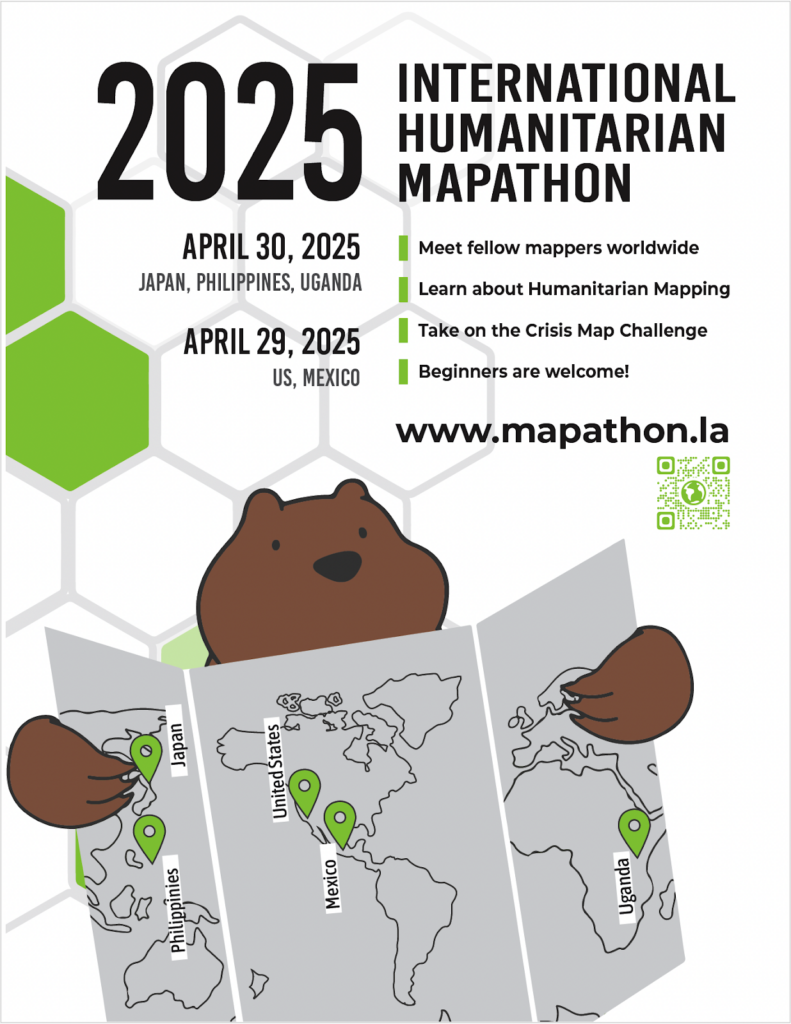
Hitotsubashi is joining the International Humanitarian Mapathon with the UN and universities abroad. The 2025 International Humanitarian Mapathon will be held on April 29, 2025 (US, Mexico) / April 30, 2025 (Japan, Philippines, Uganda).
The 2025 International Humanitarian Mapathon is a two-day, two-part global event dedicated to advancing humanitarian mapping efforts through innovation, collaboration, and community engagement. Now in its eighth year, this annual event brings together mappers, developers, and crisis response professionals from around the world to create impactful geospatial solutions for humanitarian and disaster response efforts.
The first phase, the Crisis Challenge: Mapping Human Stories, is an open invitation for participants of all skill levels—from beginners to seasoned GIS experts—to transform raw disaster data into powerful visual stories. Whether mapping earthquakes, floods, wildfires, conflicts, or refugee crises, participants are challenged to bring data to life in a way that informs, engages, and inspires action. Submissions may take the form of story-driven maps, interactive dashboards, or web applications, weaving together data, technology, and human experience. A distinguished panel, including humanitarian professionals from the United Nations, will evaluate projects based on creativity, clarity, and impact, recognizing the most compelling contributions that shed light on crisis, resilience, and recovery.
The second phase, the Humanitarian Mapathon, takes place on April 30, bringing together regional hubs and virtual participants to map a Humanitarian OpenStreetMap Task (HOTOSM) in real-time. The event will feature a keynote by Avishan Bodjnoud from the United Nations, a technologist and peacebuilder whose career was shaped by her experience growing up in wartime Tehran. Inspired by the power of technology to transcend borders and connect people, she pursued a career in IT at the UN, where she has contributed to critical peacekeeping databases, situational awareness tools, and the UN Secretary-General’s Data Strategy. Her work exemplifies how data and technology can drive global change, particularly in humanitarian and peacekeeping efforts.
With both regional and global components, the 2025 International Humanitarian Mapathon fosters a collaborative, interdisciplinary approach to mapping that strengthens humanitarian response and preparedness. Whether you’re a first-time mapper or a seasoned GIS professional, this event is an opportunity to challenge yourself, refine your skills, and use data storytelling to make a real-world impact—all while connecting with a vibrant, international community.

2025 International Humanitarian Mapathon
Participating universities and organizations
- UCLA (U.S.A.)
- Univ.Southern California (USA)
- Kyambogo University (Uganda)
- University of the Philippines (Philippines)
- Reitaku University (Japan)
- Hitotsubashi University (Japan)
- Aoyama Gakuin University (Japan)
Collaborative organizations and partners
- Maptime LA (community partner in the U.S.)
- Metro LA (public transportation in Los Angeles)
- United Nations Depart of Peace Operations (UN Headquarters)
Event Schedule
Part 1: Crisis Map Challenge
- Date: April 22 8:45-10:30 during the class of New Approaches to International Relations
- Location: Classroom 23, West Campus
Your Mission:
Map recent disasters from the past year—whether human-made (conflict, war, refugee crises) or natural (earthquakes, wildfires, floods, etc.). Your goal is to create visually compelling maps or innovative applications that reveal the risks communities face, their resilience in adversity, and their paths to recovery.
What You Can Create:
- Human Story Maps – Elevate the voices of those affected through geo-visual narratives.
- Disaster Preparedness & Response Apps – Develop mobile or web applications that help communities prepare, respond, or recover from disasters.
- Interactive Dashboards – Create real-time visualizations that inform decision-making and aid relief efforts.
- Risk & Impact Maps – Showcase hazard-prone areas, affected and/or vulnerable populations.
- Resilience & Response Maps – Highlight resources and prototype potential emergency response plans.
- Recovery & Reconstruction Maps – Track rebuilding progress, resource distribution, and assessing long-term impacts.
Key Focus Areas:
✅ Mapping Risk – Identify disaster hotspots, vulnerabilities, and threats.
✅ Visualizing Resilience – Show how communities prepare, respond, and adapt.
✅ Tracking Recovery – Highlight rebuilding efforts and ongoing challenges.
✅ Telling Human Stories – Use mapping and technology to shed light on personal experiences and lived realities.
✅ Providing Insights – Offer actionable takeaways for disaster risk reduction and policy change.
✅ Developing Tools – Build apps or interactive platforms that support preparedness, response, or recovery.
How to Submit:
To submit your project, upload your final work to our Padlet submission board at https://padlet.com/UCLA_Library/international-humanitarian-mapathon-2025-8xjwv3mztrshbiqp.
Submission Deadline: Monday, 23:59pm April 27 (we will do a local viewing contest in class next day!)
Ensure your submission includes:
- A title and brief description of your project.
- A link to your map, dashboard, or application.
- Any supporting visuals, screenshots, or documentation.
- Your team name and participant details (if applicable).
Recommended resources and tools for beginners:
– Google My Maps – Easily create and share maps.
– Google Earth Web – 3D representations of disaster locations and stories.
– Kepler.gl – Browser-based tool for visualizing geographic data.
– OpenStreetMap – Access & edit map data from around the world.
– HOTOSM Task Manager – Contribute to real-world humanitarian mapping projects.
– Canva and Google Slides – for creating presentation materials and infographics.
Advanced tools:
– QGIS – Open source GIS for advanced geographic information analysis and mapping.
– Python (Geopandas/Folium) – great for custom analysis and automation.
– Mapbox / MapLibre – for building interactive web maps and dashboards.
– Observable or Deck.gl – for data visualization.
Part 2: Humanitarian Aid Mapathon
- Date: Wednesday, April 30, 2025
- Time: 12:35 p.m.
- Location: 3d floor conference room, 3rd Research Building, East Campus
- Contents:
- Recorded keynote from the UN Department of Peace Operations
- Link up with fellow students based in Asia (and California via online briefly)
- Learn how to use OpenStreetMap
- Contribute to the HOTOSM project
- Digitally map actual buildings to support the project!
- There will also be an award ceremony for the excellent map entries in Part 1!
Best Map Award!
The “Best Map Award” will be given to the best map submitted in Part 1 (Crisis Map Challenge)! Winners will be announced during the Part 2 event. We encourage you to take the challenge!


